Mount Sabinyo, also commonly written Sabyinyo, is Uganda’s most dramatic Virunga volcano hike: a rugged, eroded peak inside Mgahinga Gorilla National Park where steep ridges, ladders, deep gullies, and cloud forest lead hikers toward the famous point where Uganda, Rwanda, and the Democratic Republic of Congo meet. Its name is often interpreted as “old man’s teeth,” a reference to the jagged summit profile.
For adventurous travelers, Mount Sabinyo hiking offers something no other Uganda mountain climb can quite match. It is not the tallest Mgahinga volcano, but it is the most distinctive. The route is physical, exposed in sections, and weather-dependent, yet the reward is a summit experience with rare geographic symbolism and outstanding Virunga scenery.
This destination combines naturally with Mgahinga Gorilla National Park, Mount Gahinga, Mount Muhabura, and Lake Bunyonyi in a well-planned Uganda safari route.
Quick Facts About Mount Sabinyo
| Feature | Details |
|---|---|
| Location | Mgahinga Gorilla National Park, Kisoro District, southwestern Uganda |
| Elevation | Commonly cited around 3,645-3,669 meters depending on source |
| Volcano Group | Virunga Mountains / Virunga Conservation Area |
| Signature Feature | Uganda-Rwanda-DRC tri-border summit area |
| Character | Rugged extinct volcano with eroded ridges and steep sections |
| Difficulty | Challenging; steep ridges, ladders, mud, altitude, and exposure |
| Typical Activity | Official guided day hike from Mgahinga Gorilla National Park |
| Best For | Fit hikers, adventure travelers, photographers, and Virunga volcano enthusiasts |
Overview of Mount Sabinyo
Mount Sabinyo is the westernmost of Uganda’s three Mgahinga volcanoes and the most sculptural. Unlike the smoother cone of Muhabura or the gentler Gahinga, Sabinyo has been heavily eroded, leaving sharp ridges and a broken summit profile. This gives the mountain its character and its challenge.
The climb is famous because the upper route reaches the border area where three countries meet. Standing near the tri-point is the symbolic highlight, but the journey is equally memorable: bamboo and montane forest, mud, ladders, ridge walking, mist, sudden views, and the physical concentration required by steep terrain.

Why Visit Mount Sabinyo?
Three-Country Summit Experience
Sabinyo’s most famous attraction is the chance to reach the point associated with Uganda, Rwanda, and the Democratic Republic of Congo. It is one of East Africa’s most unusual mountain summit experiences.
Rugged Adventure
The route is more technical-feeling than Gahinga or Muhabura, though it is still managed as a guided park hike rather than a roped alpine climb. Ladders and steep ridges add excitement and require confidence.
Excellent Virunga Atmosphere
Cloud, bamboo, forest, ridgelines, and neighboring volcano views make Sabinyo feel wild and cinematic when weather opens.
Top Things to Do on Mount Sabinyo
Complete the Guided Sabinyo Hike
The official guided hike is the central experience. Hikers should be prepared for a long day, muddy paths, steep wooden ladders, changing weather, and a descent that can be as demanding as the ascent.
Photograph the Virunga Ridges
Sabinyo is highly photogenic because of its ridges, clouds, vegetation, and summit drama. Keep cameras protected from rain and use breaks wisely; weather windows may be short.
Combine With Gahinga or Muhabura
Fit travelers can compare the three Ugandan Virunga volcanoes over several days. Gahinga is gentler, Muhabura is higher and steeper, and Sabinyo is the rugged ridge adventure.
Add Mgahinga Primate Experiences
Gorilla trekking and golden monkey tracking can be planned on separate days, creating a strong Mgahinga itinerary around wildlife and mountain adventure.
Learn more about things to do in Mount Sabinyo
Wildlife and Habitats
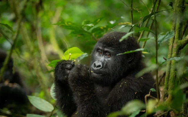
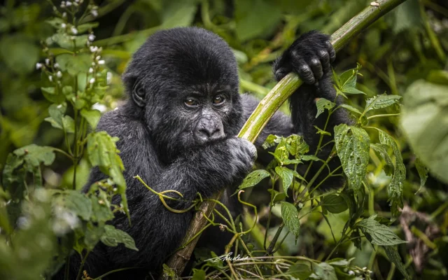
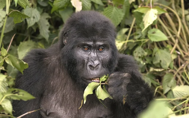
Mount Sabinyo lies inside Mgahinga Gorilla National Park, part of the Virunga Conservation Area. The mountain’s forests and bamboo zones are part of a protected landscape for mountain gorillas, golden monkeys, forest birds, and Albertine Rift biodiversity. The hike itself focuses on trekking, but the route passes through habitats that make Mgahinga globally important.
Trekking, Safari, and Culture Route Planning
Sabinyo is best planned from Kisoro or lodges near Mgahinga. Because the hike is strenuous and weather can affect pace, avoid placing it after a late arrival or before a tight transfer. It pairs well with gorilla trekking, golden monkey tracking, Lake Bunyonyi, Bwindi, and Rwanda-border itineraries.
Best Time to Hike Mount Sabinyo
Drier months from roughly June to September and December to February are generally preferred, but rain and mist are possible at any time. Wet conditions make ladders, mud, and steep sections more demanding, so good boots and waterproof layers are essential.
{{SEC_GETTING_THERE}}
Getting to Mount Sabinyo
Mount Sabinyo is accessed through Mgahinga Gorilla National Park near Kisoro. Travelers reach Kisoro by road from Kampala, Entebbe, Kabale, Lake Bunyonyi, Bwindi, or cross-border routes where practical. The hike must be arranged through official park systems or licensed operators.
Safety and Responsible Hiking
Sabinyo requires fitness, balance, and comfort with steep terrain. Follow ranger instructions, use ladders carefully, stay with the group, and be honest about fatigue. Carry water, food, rain gear, warm layers, gloves, and sturdy boots. Do not leave the trail or disturb wildlife.
Mgahinga Gorilla National Park
The park protecting Mount Sabinyo, gorillas, golden monkeys, Batwa cultural interpretation, and Uganda's Virunga volcano hikes.
Mount Gahinga
A gentler Virunga volcano hike and useful contrast to Sabinyo's rugged ridges and ladders.
Mount Muhabura
The tallest Mgahinga volcano, offering a steep stamina test and summit crater lake.
Lake Bunyonyi
A scenic lake retreat for rest, canoeing, and recovery after the demanding Sabinyo hike.
Bwindi Impenetrable National Park
A major gorilla trekking extension that pairs well with Mgahinga volcano and primate itineraries.
Sample Itinerary Ideas
A strong Sabinyo itinerary includes arrival in Kisoro, the Sabinyo hike, a recovery day or golden monkey tracking, then gorilla trekking or Lake Bunyonyi. Ambitious hikers can add Gahinga or Muhabura on separate days, but rest makes the experience safer and more enjoyable.
Why Mount Sabinyo Is the Most Demanding Virunga Hike in Uganda
Sabinyo’s ridges are steep, muddy, and often exposed. The reward is the rare chance to stand where Uganda, Rwanda, and the Democratic Republic of Congo meet at the summit area. This transboundary setting makes Sabinyo one of the most memorable volcano hikes in the region.
Only attempt Sabinyo with official guides, proper footwear, and realistic fitness. It is not the right peak for travelers who want a gentle forest walk.
Custom Safari Planning for Mount Sabinyo
When you add Mount Sabinyo to a Uganda itinerary, treat it as a purposeful route decision rather than an afterthought. The best visits combine realistic drive times, local guiding, and nearby destinations that share geography or travel theme.
Start with how many nights you can spend in the area, whether you need an arrival or departure buffer, and whether the stop is mainly for wildlife, culture, scenery, adventure, or logistics. That framing helps you choose the right base, guide, and activity timing.
Strong Nearby Pairings
Many itineraries combine Mount Sabinyo with Mgahinga Gorilla National Park. The park protecting Mount Sabinyo, gorillas, golden monkeys, Batwa cultural interpretation, and Uganda's Virunga volcano hikes.
Many itineraries combine Mount Sabinyo with Mount Gahinga. A gentler Virunga volcano hike and useful contrast to Sabinyo's rugged ridges and ladders.
Many itineraries combine Mount Sabinyo with Mount Muhabura. The tallest Mgahinga volcano, offering a steep stamina test and summit crater lake.
Many itineraries combine Mount Sabinyo with Lake Bunyonyi. A scenic lake retreat for rest, canoeing, and recovery after the demanding Sabinyo hike.
Timing, Guides and Expectations
Morning starts often work best for cooler weather, smoother traffic, and better light. Confirm opening hours, boat or ferry schedules, permit rules, and guide availability before travel because local operations can change seasonally.
Use respectful travel habits throughout: ask before photographing people, follow site or park rules, support community-led experiences where possible, and keep expectations accurate for the destination type. This approach makes Mount Sabinyo feel like a meaningful part of your Uganda story rather than a rushed checkbox stop.
If you want help building a route that includes Mount Sabinyo, our team can suggest whether it works best as a half-day visit, overnight base, or multi-day regional extension.
Why Mount Sabinyo Is the Most Demanding Virunga Hike in Uganda
Sabinyo’s ridges are steep, muddy, and often exposed. The reward is the rare chance to stand where Uganda, Rwanda, and the Democratic Republic of Congo meet at the summit area. This transboundary setting makes Sabinyo one of the most memorable volcano hikes in the region.
Only attempt Sabinyo with official guides, proper footwear, and realistic fitness. It is not the right peak for travelers who want a gentle forest walk.
Preparation and Recovery
Plan a full day for Sabinyo alone and avoid scheduling another strenuous activity the same day. Trekking poles, gloves, and waterproof layers are strongly recommended. Overnight in Kisoro before and after the hike makes early starts easier.
- How high is Mount Sabinyo?
-
Mount Sabinyo is commonly cited around 3,645 to 3,669 meters above sea level, depending on the source and spelling used.
- Where is Mount Sabinyo?
-
Mount Sabinyo is inside Mgahinga Gorilla National Park in southwestern Uganda, on the Virunga border landscape shared by Uganda, Rwanda, and the DRC.
- Is Mount Sabinyo difficult?
-
Yes. Sabinyo is a challenging hike with steep ridges, ladders, mud, altitude, and exposed-feeling sections.
- Can you stand in three countries on Mount Sabinyo?
-
The summit area is famous for the Uganda-Rwanda-DRC tri-border experience, which is the symbolic highlight of the hike.
- Do I need a permit for Mount Sabinyo?
-
Yes. Sabinyo hikes are arranged through official Mgahinga Gorilla National Park systems or licensed operators.
- Which is harder, Sabinyo or Muhabura?
-
Muhabura is higher and more sustained, while Sabinyo is more rugged, steeper in sections, and more exposed because of ridges and ladders.